
A New Warning Emerges in the Upper Bhagirathi Valley
Nearly a year after the devastating mudflow that reshaped Dharali and parts of the Harsil valley in Uttarakhand, fresh satellite observations have revealed a development that has once again raised concerns among scientists, local residents, and disaster management authorities. Recent imagery shows a newly formed water pool upstream of the debris left behind by the August 2025 disaster, suggesting that the Bhagirathi River continues to be affected by the massive geological changes triggered by the mudflow.
The formation of this temporary water body comes at a time when the southwest monsoon has intensified over the Himalayan region. Combined with seasonal snowmelt and glacier-fed discharge, the growing pool has renewed fears of possible downstream hazards if the accumulated water is suddenly released.
This latest development highlights how mountain disasters often continue long after the initial event, with altered landscapes creating new risks for communities living downstream.
Looking Back at the 2025 Dharali Disaster
On August 5, 2025, a catastrophic debris flow struck the Dharali-Harsil region in Uttarkashi district. Massive volumes of mud, rocks, and sediment originating from the Tel Gad and Kheer Gad streams rushed into the Bhagirathi valley, destroying homes, roads, and public infrastructure.
The event dramatically altered the river’s natural course. Large quantities of debris settled across the valley floor, partially blocking the Bhagirathi River and forcing it into a narrower channel.
Satellite observations made immediately after the disaster showed significant geomorphological changes, including widened riverbanks, buried settlements, and extensive sediment deposits. Experts later concluded that the river’s behavior had fundamentally changed because of the obstruction created by the debris.
What the Latest Satellite Images Show
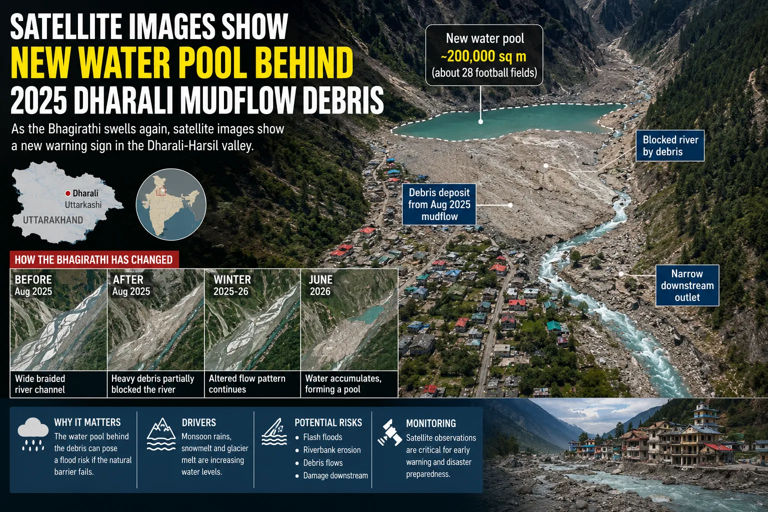
The newest satellite imagery captured through the European Union’s Copernicus Sentinel-2 programme indicates that a localized water pool has developed upstream of the Dharali debris deposits.
According to the imagery analysis, the water body now covers nearly 200,000 square metres, roughly equivalent to the size of about 28 football fields.
Rather than flowing freely through its original channel, the Bhagirathi River now appears to slow down behind the accumulated sediment and boulders before passing through a much narrower downstream outlet.
Time-series satellite images comparing conditions before and after the disaster clearly demonstrate how the river has evolved:
-
Before the 2025 mudflow, the Bhagirathi followed a broad braided channel.
-
After the disaster, heavy sediment deposits partially blocked the river.
-
During the winter of 2025-26, the altered flow pattern remained largely unchanged.
-
By June 2026, water accumulation had become much more pronounced, eventually forming a distinct pond upstream of the debris barrier.
These observations indicate that the debris deposit continues to influence river hydraulics nearly a year after the disaster.
Why the Water Pool Matters
Temporary lakes or water pools formed behind landslide or debris barriers are well-known hazards in mountainous regions.
Unlike engineered dams, these natural barriers consist primarily of loose sediment, rocks, and unconsolidated debris. Their stability depends on many factors, including rainfall intensity, water pressure, and erosion.
As monsoon rains continue, increasing volumes of water enter the upper Bhagirathi basin through multiple sources:
-
Seasonal rainfall
-
Snowmelt
-
Glacier-fed streams
-
Surface runoff from surrounding mountains
If the natural debris barrier weakens or collapses, large quantities of stored water and sediment could be released rapidly downstream.
Such releases can trigger:
-
Flash flooding
-
Riverbank erosion
-
Channel shifts
-
Fresh debris flows
-
Damage to infrastructure located along the river corridor
Although experts have not concluded that such a failure is imminent, they stress that continued monitoring is essential.
Scientific Perspective on the Situation
Researchers studying the satellite imagery have noted that the narrowing of the Bhagirathi channel appears to be responsible for the current accumulation of water.
According to glacier and glacial lake outburst flood (GLOF) researcher Ashim Sattar of IIT Bhubaneswar, the present swelling is likely linked to increased monsoon runoff combined with seasonal glacier melt.
He has also cautioned that while the area is not necessarily facing an immediate emergency, it cannot yet be considered completely safe without detailed hydrological and geological assessment.
This cautious scientific approach reflects the complexity of Himalayan river systems, where multiple natural processes often interact simultaneously.
Glacier Changes Add Another Dimension
The latest Sentinel-2 imagery has also documented visible changes in the glacier-fed catchments located above Dharali.
Comparisons between imagery from 2025 and 2026 reveal:
-
Reduced snow cover
-
Retreating seasonal snowlines
-
Greater exposure of rock surfaces
-
More visible meltwater channels
These observations suggest increased seasonal melting in the upper watershed.
While seasonal snow retreat is expected during warmer months, scientists note that sustained glacier retreat can influence river discharge patterns over time. Increased meltwater entering already swollen rivers during the monsoon may further elevate downstream risks.
Understanding River Channel Changes
One of the most significant findings from the satellite analysis is the alteration of the Bhagirathi River’s natural flow path, also known as its thalweg.
The thalweg represents the deepest portion of a river channel where water naturally concentrates.
Following the 2025 debris flow, this pathway shifted because the accumulated sediment occupied part of the original channel.
As a result:
-
Water now flows through a more confined downstream passage.
-
Flow velocity changes across different sections.
-
Upstream ponding becomes more likely.
-
Sediment transport patterns continue to evolve.
These river adjustments may continue for several years before reaching a new natural equilibrium.
Importance of Satellite Monitoring
Modern satellite technology has become an indispensable tool for monitoring natural hazards in remote Himalayan terrain.
Repeated observations from Earth-observation satellites allow scientists to:
-
Detect landscape changes after disasters.
-
Measure river channel shifts.
-
Track newly formed lakes.
-
Monitor snow and glacier conditions.
-
Assess sediment movement.
-
Identify emerging hazards before they become visible from the ground.
Such monitoring supports disaster preparedness by providing authorities with valuable information for planning inspections, evacuations if necessary, and infrastructure protection.
Challenges for Himalayan Disaster Management
The Dharali case illustrates a broader challenge facing Himalayan states.
Many valleys remain vulnerable to a combination of:
-
Extreme rainfall
-
Landslides
-
Glacier-related hazards
-
River erosion
-
Sediment accumulation
Climate variability, expanding infrastructure, and growing populations in mountainous regions make effective hazard monitoring increasingly important.
Experts continue to recommend stronger early-warning systems, improved hydrological monitoring, detailed geological surveys, and regular satellite-based assessments to reduce future disaster risks.
The Road Ahead
The newly observed water pool behind the Dharali mudflow debris does not automatically indicate that a major disaster is imminent. However, it serves as an important reminder that the impacts of the 2025 event are still unfolding.
As the monsoon progresses, continuous monitoring of the Bhagirathi River, debris deposits, and surrounding glaciers will be critical. Field investigations combined with satellite observations can help authorities determine whether the natural obstruction remains stable or requires intervention.
For local communities, this development underscores the importance of preparedness and timely information. The Himalayas are among the world’s most dynamic mountain systems, where rivers and landscapes can change rapidly after extreme weather events.
The Dharali valley’s experience demonstrates that the aftermath of a natural disaster often extends far beyond the initial destruction. Careful scientific observation, responsible planning, and proactive disaster management will play a vital role in protecting lives and infrastructure as Uttarakhand continues to navigate the challenges of an evolving mountain environment.
